Shanghai Suzhou Creek Walk: Bridges, Industry and Skyline Views
On this page14 sections
- 01Route at a glance
- 02Stop 1: Sihang Warehouse
- 03Follow the creek, not the fastest road
- 04The bridge sequence
- 05Shanghai Postal Museum area
- 06Zhapu Road Bridge: the skyline transition
- 07Waibaidu Bridge and where the creek ends
- 08Best time and weather
- 09Architecture without overclaiming
- 10Accessibility and pacing
- 11Food and rest strategy
- 12A practical schedule
- 13Frequently asked questions
- 14Sources
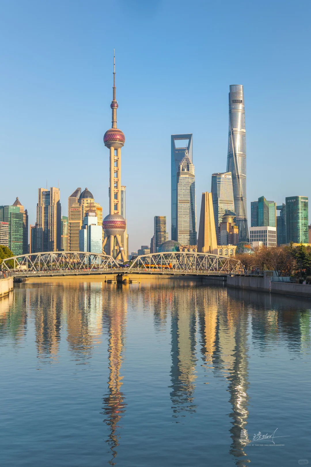
Walk the final stretch of Suzhou Creek from Sihang Warehouse toward the Huangpu River to see a version of Shanghai that the Bund alone cannot explain. The route passes a wartime memorial, former industrial and financial buildings, a sequence of historic bridges, the Postal Museum area, Zhapu Road Bridge and Waibaidu Bridge. The core line is compact, but allow two to three hours with stops.
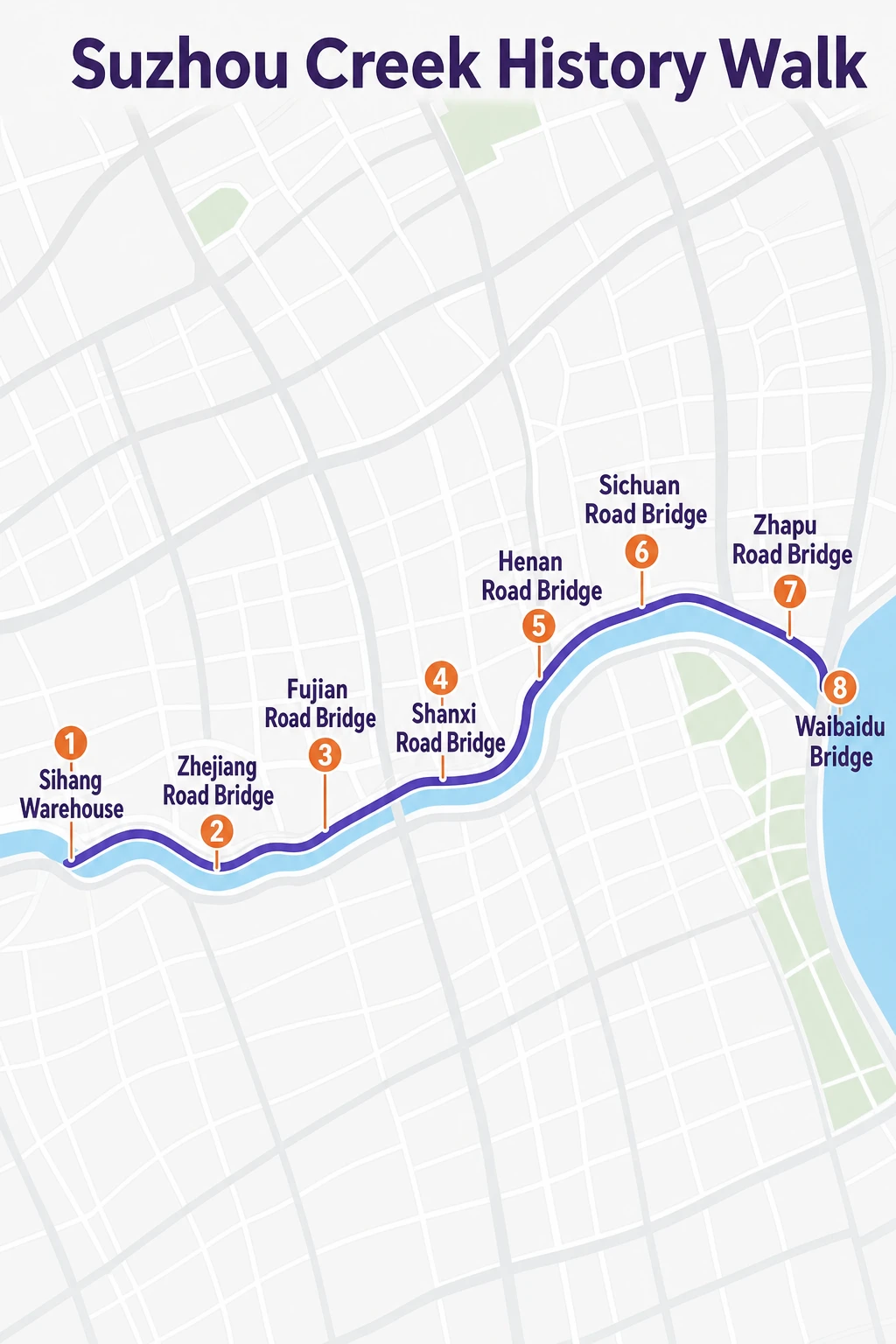
Start at Sihang Warehouse and walk east. This direction lets the skyline grow gradually until the creek meets the Huangpu near the Bund. It also keeps the route's history in sequence: storage and industry first, then civic architecture and the global-city view.
Route at a glance
Start: Sihang Warehouse/War Memorial area Bridges and stops: Zhejiang Road Bridge → Fujian Road Bridge → Shanxi Road Bridge → Shanghai Postal Museum → Zhapu Road Bridge → Waibaidu Bridge Finish: North Bund or the Bund Core distance: roughly 2 km, depending on riverbank access and detours Realistic time: two to three hours Best light: late afternoon into blue hour
The popular 2026 XHS route described the core as about an hour. That is walking time without meaningful stops. If you plan to read memorial displays, visit a museum or wait for photographs, reserve much longer.
Stop 1: Sihang Warehouse
Sihang Warehouse is the historical anchor. The building is associated with the 1937 defense of the warehouse during the Battle of Shanghai, and its preserved western wall makes the conflict physically visible in the cityscape.
Check the current museum access, reservation requirements and opening days before going. Even if the interior is unavailable, the exterior and memorial context establish why this is not merely a waterfront photo walk.
Look across the creek and around the surrounding blocks. Warehouses and commercial buildings belonged to a logistics landscape that connected river transport, finance and urban growth. Shanghai's official industrial-heritage routes use Suzhou Creek precisely because this infrastructure still reads in the built environment.
Follow the creek, not the fastest road
From Sihang Warehouse, move east along the publicly accessible river edge where current construction permits. Shanghai continues to improve the Suzhou Creek waterfront, so a saved route can meet a temporary closure or diverted promenade.
If the riverside path closes, cross at the next bridge and rejoin rather than walking through a construction barrier. The north and south banks offer different façades, and switching sides is part of the route rather than a failure.
Use AMap or Apple Maps for live pedestrian access. Google Maps should not be the only navigation source in mainland China; see our China map-app comparison for setup.
The bridge sequence
Zhejiang Road, Fujian Road and Shanxi Road bridges break the walk into short chapters. Their structures, materials and street connections show how the creek served transport as well as scenery.
Do not stand in a bicycle lane or road shoulder for a symmetrical photograph. Use the pedestrian path and cross only where permitted. Some of the best views come from looking diagonally along the creek rather than from the middle of a bridge.
The waterway is working urban infrastructure. Tour boats, flood-control structures, restored façades and new public space exist together. That tension is more interesting than treating every building as “European Shanghai.”
Shanghai Postal Museum area
The Shanghai Postal Museum occupies a landmark building near the creek and offers a strong civic-architecture stop. Verify the museum's current opening schedule and entry process; many Shanghai museums close on a regular weekday or require a booking.
Even without entering, look at the building's relationship to the water and bridge network. Postal systems, shipping and finance depended on the same connected city that warehouses served farther west.
This is a good rest point. If the weather is poor, make the museum the main indoor stop and shorten the remaining outdoor route.
Zhapu Road Bridge: the skyline transition
Zhapu Road Bridge is one of the route's most popular skyline viewpoints. From here, historic riverside architecture and the Lujiazui towers appear in the same frame. Shanghai's official citywalk material includes this area in architecture routes linking Waitanyuan, historic buildings and the creek.
Late afternoon light can be excellent, but the bridge becomes busy. Keep moving, do not occupy the full pedestrian width with a tripod and avoid photographing people at close range without consent.
The bridge also marks a shift in the walk. West of it, industrial and transport history dominates. East of it, the visual pull of the Bund and Huangpu becomes stronger.
Waibaidu Bridge and where the creek ends
Continue to Waibaidu Bridge, where Suzhou Creek reaches the Huangpu. The steel bridge is a recognizable Shanghai landmark, but it makes more sense after the upstream walk: you arrive knowing that the smaller river behind it carried its own commercial and industrial world.
From here, choose your finish:
cross toward the Bund for the classic waterfront;
continue on the north side toward North Bund public space;
stop for dinner around the Sichuan North Road/Hongkou edge;
take the metro or DiDi rather than adding another long walk; set up ride-hailing in advance with our DiDi guide for foreign visitors.
Do not automatically combine this route with the entire Bund, Nanjing Road and Yu Garden in one day. That turns a coherent two-hour walk into an exhausting checklist. For a different infrastructure-led city walk, save the Hangzhou Grand Canal water-bus route for a separate Hangzhou day.
Best time and weather
Morning
Best for quieter bridges and museum timing. Skyline light can be flat or hazy depending on conditions.
Late afternoon
Best transition from architecture detail to sunset and blue-hour skyline. Confirm museum closing time if an interior visit matters.
Rain
Reflections can look excellent, but bridges become slippery and wind near the Huangpu can be strong. Keep an indoor alternative and do not shelter in a way that blocks building entrances.
Summer heat
The creek has exposed sections. Start later, carry water and use the Postal Museum or a legitimate café as a cooling break.
Architecture without overclaiming
This route crosses buildings from different periods and uses. Avoid assigning a style or date from appearance alone. If you want a deeper architecture walk, use the Shanghai government's published citywalk routes or a specialist guide who can distinguish original fabric from restoration.
Industrial heritage is not synonymous with abandonment. Many buildings have new uses, and some remain operational or private. Respect fences and access notices.
Accessibility and pacing
The main promenade and bridges include many accessible sections, but temporary works, curb transitions and bridge approaches can interrupt a fully step-free line. Check the current pedestrian route and be willing to switch banks or use a short ride.
Travelers with limited energy can start at the Postal Museum and walk only the final skyline section to Waibaidu Bridge. History-focused visitors should start at Sihang Warehouse and skip the Bund extension.
Do not cross every bridge simply because it is on the route. The best bank can change with construction, shade and the next building you want to enter. Look ahead at the next two stops, cross once when it improves the sequence, and avoid repeated stair approaches. If a promenade section is closed, use the nearest legal street detour rather than stepping into a cycle lane or fenced work area.
Food and rest strategy
Eat before starting or plan one deliberate stop near the Postal Museum/Zhapu Road area. The immediate waterfront can be more expensive and less convenient than streets a few blocks away. Search by current ratings and opening status, not a fixed viral café list.
Keep the route's final hour flexible. If sunset is good, stay on the bridge sequence; if haze is heavy, spend more time inside a museum or at the memorial.
A practical schedule
15:00: Sihang Warehouse exterior and memorial context.
15:45: begin walking east along the creek.
16:15–17:00: bridge sequence and architecture stops.
17:00–17:45: Postal Museum area or rest.
17:45–18:30: Zhapu Road Bridge and Waibaidu Bridge.
After 18:30: Bund, North Bund or dinner.
Shift the entire plan earlier in winter and check current sunset and venue hours.
Frequently asked questions
Is the Suzhou Creek walk free?
Public waterfront and bridges are generally free. Museums, exhibitions, cruises or special venues can have separate reservations or charges.
Which direction is better?
West to east creates the strongest narrative and finishes with the skyline. Reverse it if transport or sunset location makes more sense.
Can I do the walk in one hour?
You can cover the core distance briskly, but two to three hours is more realistic for history, photography and a museum or rest stop.
Is this route near the Bund?
It ends near the northern end of the Bund at Waibaidu Bridge. The starting point at Sihang Warehouse is farther west along Suzhou Creek.
Sources
Shanghai government: architecture citywalk to Zhapu Road Bridge, published 2024.
Shanghai government: Suzhou Creek industrial heritage, published 2025.
XHS route inspiration, note 69f8ac53000000001f007600, published 2026-05-04; engagement collected 2026-07-16.